
This geography problem is solved step by step below, with detailed explanations to help you understand the method and arrive at the correct answer.
ScanSolve AI Answer
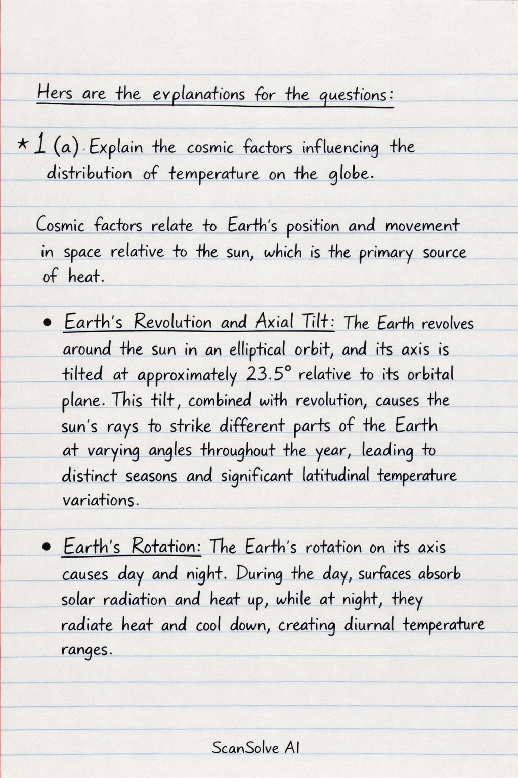
Here are the explanations for the questions: 1. (a) Explain the cosmic factors influencing the distribution of temperature on the globe. Cosmic factors relate to Earth's position and movement in space relative to the sun, which is the primary source of heat. • Earth's Revolution and Axial Tilt: The Earth revolves around the sun in an elliptical orbit, and its axis is tilted at approximately 23.5^ relative to its orbital plane. This tilt, combined with revolution, causes the sun's rays to strike different parts of the Earth at varying angles throughout the year, leading to distinct seasons and significant latitudinal temperature variations. • Earth's Rotation: The Earth's rotation on its axis causes day and night. During the day, surfaces absorb solar radiation and heat up, while at night, they radiate heat and cool down, creating diurnal temperature ranges. • Eccentricity of Earth's Orbit: The elliptical shape of Earth's orbit means its distance from the sun varies throughout the year. While this has a minor direct effect on seasonal temperatures, it influences the total solar radiation received over longer geological timescales (Milankovitch cycles). • Solar Output Variations: Changes in the sun's energy output, such as those associated with sunspot cycles, can cause slight fluctuations in the amount of solar radiation reaching Earth, potentially influencing global temperatures over decades or centuries. 1. (b) Compare the characteristics of the tropical rainforest climate and that of the tropical continental climate. | Characteristic | Tropical Rainforest Climate (Equatorial/Af) | Tropical Continental Climate (Savanna/Aw) | |-----------------------|---------------------------------------------------------------------------|----------------------------------------------------------------------------| | Location | Typically 0^ to 10^ North and South of the Equator. | Typically 10^ to 25^ North and South of the Equator. | | Temperature | High and constant throughout the year (25^ to 30^), small annual range. | High, but with a larger annual range. Distinct hot and cooler seasons. | | Rainfall | Very high (over 2000 mm/year), well-distributed throughout the year with no distinct dry season. Convectional rainfall is dominant. | Seasonal, with a distinct wet season (summer) and a distinct dry season (winter). Total rainfall is lower (500 mm to 1500 mm/year). | | Humidity | Very high and constant. | Varies significantly between the wet and dry seasons. | | Vegetation | Dense, multi-layered evergreen broadleaf forest (Selva). | Grasslands with scattered trees and shrubs (savanna). | 1. (c) In each of the drainage basins in Cameroon, show and explain briefly the nature of the drainage basins. Cameroon is characterized by three main drainage basins: • Atlantic Basin: This basin covers the western and southern parts of Cameroon, draining directly into the Atlantic Ocean. It is characterized by numerous short, fast-flowing rivers such as the Wouri, Sanaga, and Nyong. The nature of this basin is largely influenced by high rainfall, dense tropical rainforest cover, and a relatively steep gradient towards the coast, leading to significant water discharge and potential for hydroelectric power. • Congo Basin: The southeastern part of Cameroon forms part of the vast Congo River basin. Rivers like the Dja and Kadéï flow south-eastwards to join the Congo River system. This basin is characterized by extensive, relatively flat terrain, dense equatorial rainforest, and a network of meandering rivers with generally slower flow rates compared to the Atlantic basin. It is a region of high biodiversity and significant water resources. • Lake Chad Basin: Located in the northern part of Cameroon, this basin drains into Lake Chad, an endorheic (inland) lake. Major rivers in this basin include the Logone and Chari. The nature of this basin is semi-arid, with seasonal rivers that experience significant fluctuations in water levels between the wet and dry seasons. The vegetation is predominantly savanna, and the basin is crucial for agriculture and pastoralism, though it faces challenges from desertification and water scarcity. 2. (a) Explain the mechanisms responsible for the movement of plates in the interior of the earth. The movement of tectonic plates is primarily driven by heat generated within the Earth's interior, leading to convection currents in the mantle. • Mantle Convection: The Earth's mantle is a semi-fluid layer where heat from the core and radioactive decay causes material to slowly circulate. Hot, less dense mantle material rises towards the surface, spreads out beneath the lithosphere, cools, becomes denser, and then sinks back down. This continuous cycle creates convection cells that drag the overlying tectonic plates. • Ridge Push: At mid-ocean ridges, new oceanic crust is formed from rising magma. This new crust is hot and buoyant, causing it to sit at a higher elevation. Gravity then causes this elevated, newly formed lithosphere to slide down the gentle slope away from the ridge, pushing the entire plate ahead of it. • Slab Pull: This is considered the most significant driving force. At subduction zones, cold, dense oceanic lithosphere sinks back into the mantle. As the dense slab descends, its weight pulls the rest of the plate along behind it, much like a tablecloth sliding off a table. The greater the density and length of the subducting slab, the stronger the slab pull force. • Mantle Drag: The friction between the circulating mantle material and the base of the lithospheric plates also contributes to the movement, either by dragging the plates along or by resisting their motion. 2. (b) Explain any THREE hard engineering methods that can be used to sustainably manage coastal landscape. Hard engineering methods involve constructing artificial structures to protect coastal areas. For sustainable management, these methods aim for long-term effectiveness with minimal negative environmental impact. • Sea Walls: These are large concrete or rock barriers built parallel to the coast to absorb wave energy and prevent erosion and flooding. For sustainability, they can be designed with stepped profiles to dissipate wave energy more effectively, reducing scour, and can incorporate features that allow for ecological colonization, though their construction is often resource-intensive and can alter natural coastal processes. • Groynes: These are timber, rock, or concrete structures built perpendicular to the coastline, extending into the sea. Their purpose is to trap sediment transported by longshore drift, thereby building up and maintaining a wider beach. Sustainably, groynes help maintain natural beach defenses, but careful planning is needed to ensure they do not excessively starve down-drift beaches of sediment, which could lead to increased erosion elsewhere. • Rock Armour (Rip-rap): This involves placing large, angular boulders at the base of cliffs or along the shoreline. The irregular surface of the rocks dissipates wave energy, protecting the land behind them from erosion. Rock armour is durable and can be relatively low-maintenance. From a sustainability perspective, it can create habitats for marine life within the gaps between the rocks and is often a more natural-looking solution than concrete walls, though sourcing and transporting the rocks can have environmental impacts. 2. (c) Comment on the relief characteristics of the Cameroon volcanic line (CVL). The Cameroon Volcanic Line (CVL) is a prominent geological feature characterized by a chain of volcanoes and volcanic massifs extending from the Atlantic Ocean (Pagalu Island) through mainland Cameroon to the interior. • Linear Arrangement: The most striking characteristic is its linear alignment, stretching for over 1600 km from the Atlantic into the continent. • High Elevations: The CVL features some of the highest peaks in West and Central Africa, notably Mount Cameroon, which