This geography problem is solved step by step below, with detailed explanations to help you understand the method and arrive at the correct answer.
ScanSolve AI Answer
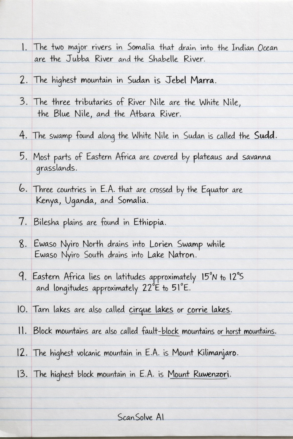
1. The two major rivers in Somalia that drain into the Indian Ocean are the Jubba River and the Shabelle River. 2. The highest mountain in Sudan is Jebel Marra. 3. The three tributaries of River Nile are the White Nile, the Blue Nile, and the Atbara River. 4. The swamp found along the White Nile in Sudan is called the Sudd. 5. Most parts of Eastern Africa are covered by plateaus and savanna grasslands. 6. Three countries in E.A. that are crossed by the Equator are Kenya, Uganda, and Somalia. 7. Bilesha plains are found in Ethiopia. 8. Ewaso Nyiro North drains into Lorien Swamp while Ewaso Nyiro South drains into Lake Natron. 9. Eastern Africa lies on latitudes approximately 15°N to 12°S and longitudes approximately 22°E to 51°E. 10. Tarn lakes are also called cirque lakes or corrie lakes. 11. Block mountains are also called fault-block mountains or horst mountains. 12. The highest volcanic mountain in E.A. is Mount Kilimanjaro. 13. The highest block mountain in E.A. is Mount Ruwenzori. 14. The main longitude is called the Prime Meridian. 15. The largest country in Eastern Africa is Sudan. 16. Imaginary lines that run from West to East are called latitudes or parallels of latitude. 17. The water body found to the North East of Eastern Africa is called the Red Sea. 18. Three countries that border Eastern Africa to the south are Mozambique, Zambia, and Zimbabwe. 19. The Equator divides the earth into two equal halves called the Northern Hemisphere and the Southern Hemisphere. 20. Five landlocked countries in Eastern Africa are: a) Uganda b) Rwanda c) Burundi d) South Sudan e) Ethiopia 21. There are 90 degrees of latitudes in the northern hemisphere. 22. The earth has a total of 360 degrees of longitudes. Send me the next one 📸